파일:NOAA Photo of World Trade Center Site, September 23, 2001 (NOAA LOC) (2076394634).jpg

문서 내용이 다른 언어로는 지원되지 않습니다.
위키배움터

원본 파일(11,339 × 11,306 픽셀, 파일 크기: 53.18 MB, MIME 종류: image/jpeg)

이 파일은 위키미디어 공용에 있으며, 다른 프로젝트에서 사용하고 있을 가능성이 있습니다. 해당 파일에 대한 설명이 아래에 나와 있습니다.

주의 이 그림은 크기가 상당히 크며, 일부 브라우저의 경우 그림을 실제 크기로 표시할 때 프로그램이 멈출 수 있습니다. 이 경우, '최대 해상도' 링크 위에서 마우스 오른쪽 버튼을 눌러서 컴퓨터 파일로 저장한 다음, 포토샵이나 GIMP 같은 편집기를 이용해서 파일을 열어 주세요.
설명
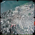
English: Image taken by NOAA's Cessna Citation Jet during Sept. 23, 2001 from an altitude of 3,300 feet using a Leica/LH systems RC30 camera.

Original description by LOC:


World Trade Center, September 23, 2001.

United States. National Oceanic and Atmospheric Administration.
CREATED/PUBLISHED
[Washington, D.C.] : National Oceanic and Atmospheric Administration, [2001]
NOTES
On accompanying NOAA exhibit identification sign: Aerial photograph of the World Trade Center, taken by National Oceanic and Atmospheric Administration on September 23, 2001, from an altitude of 3,300 feet, showing the devastation and the ongoing recovery effort.
Vertical col. glossy photograph from aircraft graduating to oblique in all directions.
Also covers surrounding undamaged districts.
Title from accompanying exhibit identification sign.
Oriented with north toward the upper right.
Printed on: Kodak Professional paper.
Includes alphanumeric technical photographic data in lower margin.
In right margin in red box: WILD 16/4 UAGA-f, Nr 13164 153,28.
Scale [ca. 1:1,500 at center].
SUBJECTS
World Trade Center (New York, N.Y.)--Remote-sensing images.
World Trade Center (New York, N.Y.)--Aerial views.
September 11 Terrorist Attacks, 2001--Maps.
Wall Street (New York, N.Y.)--Remote-sensing images.
Wall Street (New York, N.Y.)--Aerial views.
United States--New York (State)--Wall Street (New York)
MEDIUM
1 remote-sensing image : col., photocopy ; 92 x 93 cm. + 1 exhibit identification sign ([1] sheet : 9 x 39 cm.)
CALL NUMBER
G3804.N4:2W7A43 2001 .U5 Vault Oversize
REPOSITORY
Library of Congress Geography and Map Division Washington, D.C. 20540-4650 USA
DIGITAL ID
g3804n ct002130 http://hdl.loc.gov/loc.gmd/g3804n.ct002130
날짜
출처
This image is available from the United States Library of Congress's Geography & Map Division
under the digital ID g3804n.ct002130.
This tag does not indicate the copyright status of the attached work. A normal copyright tag is still required. See Commons:Licensing.

العربية  беларуская (тарашкевіца)  বাংলা  čeština  Deutsch  English  español  فارسی  suomi  français  galego  עברית  magyar  Bahasa Indonesia  italiano  日本語  lietuvių  македонски  മലയാളം  Nederlands  polski  português  português do Brasil  română  русский  sicilianu  slovenčina  slovenščina  Türkçe  українська  简体中文  繁體中文  +/−

저자 National Oceanic and Atmospheric Administration
저작권
(이 파일을 인용하기)
Public domain
이 파일은 NOAA에서 제작하였으므로 퍼블릭 도메인입니다. 고용인의 공식 업무 과정 동안 만들어졌습니다.

العربية  čeština  Deutsch  Zazaki  English  español  eesti  suomi  français  hrvatski  magyar  italiano  日本語  한국어  македонски  മലയാളം  Plattdüütsch  Nederlands  polski  português  română  русский  sicilianu  slovenščina  Türkçe  Tiếng Việt  简体中文  繁體中文  +/−

다른 버전

이 파일은 다음으로 파생됨:  World Trade Center Site 9-23-01 with Cordoba House location.jpg

설명

이 파일이 나타내는 바에 대한 한 줄 설명을 추가합니다

이 파일에 묘사된 항목

다음을 묘사함

파일 역사

날짜/시간 링크를 클릭하면 해당 시간의 파일을 볼 수 있습니다.

날짜/시간섬네일크기사용자설명
현재2010년 6월 28일 (월) 01:402010년 6월 28일 (월) 01:40 판의 섬네일11,339 × 11,306 (53.18 MB)Trycatchhigher resolution from the same source; converted from JPEG2000 to JPEG, Quality=95, subsampling 4:4:4
2007년 12월 30일 (일) 20:362007년 12월 30일 (일) 20:36 판의 섬네일354 × 352 (46 KB)File Upload Bot (Magnus Manske) {{Information |Description= Public Domain. Suggested credit: NOAA/Library of Congress via pingnews. Additional information from source: World Trade Center, September 23, 2001. United States. National Oceanic and Atmospheric Administration. CREATED

이 파일을 사용하고 있는 모든 위키의 문서 목록

다음 위키에서 이 파일을 사용하고 있습니다:

  • ko.wiktionary.org에서 이 파일을 사용하고 있는 문서 목록

메타데이터